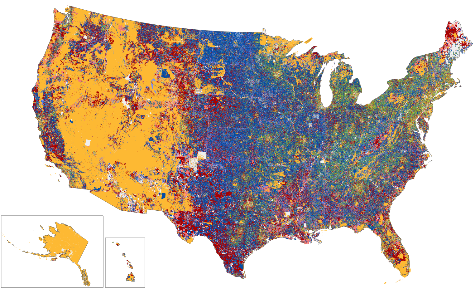
The Challenge: Property Data Access
Land ownership impacts housing affordability, gentrification, generational wealth, climate risk, and environmental conservation. At the heart of many community issues lies a seemingly simple question: “Who owns the land?”
But the answer is not so easy to obtain. Land ownership data is inaccessible, fragmented, outdated, incomplete, and obscured — making it largely unusable.

The Solution: WHOA
Our team provides the most comprehensive, hyper-accurate source of property ownership information across the United States. Our Who Owns America analysis makes it possible to quickly and effectively get to the heart of key issues with real answers about ownership realities and trends.
Helping Communities Unlock the Black Box of Ownership Data

Real Answers
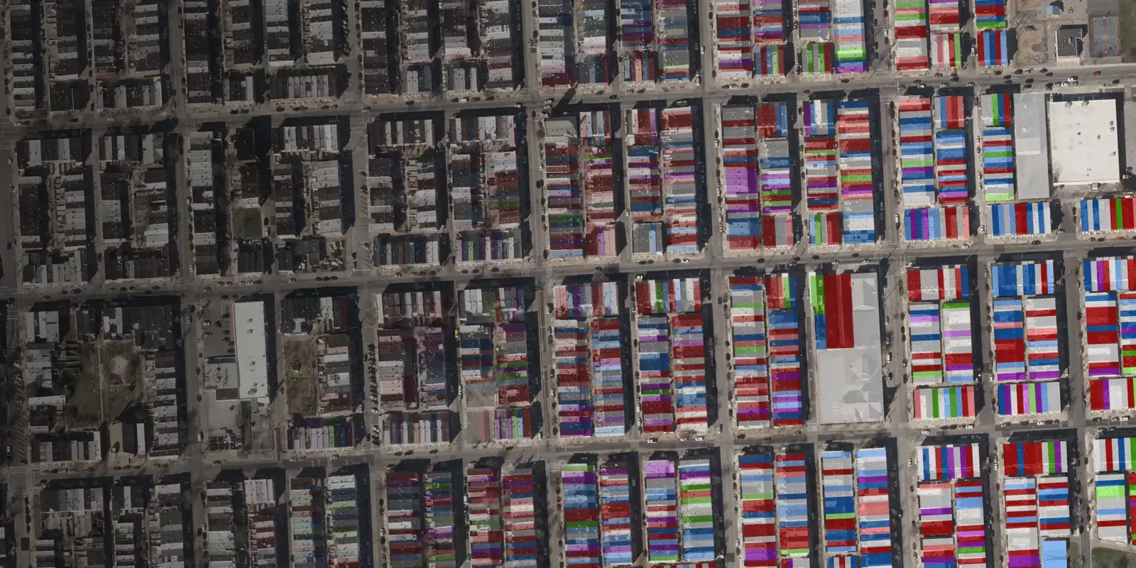
By examining property information parcel-by-parcel, WHOA traces ownership across geographic borders and corporate structures for the most accurate assessment of who owns what.

Complete Snapshot
You can’t address what you don’t understand. WHOA provides robust parcel ownership analysis and comprehensive insights into property ownership data to empower informed decision-making.

Accurate & Simple
Understand ownership as communities grow and change. WHOA combines multiple authoritative data sources, vetted with clients’ on-the-ground expertise, to reveal who owns what with 16 easy-to-understand ownership categories.

360° Perspective
Parcel data is just one part of the picture. CGS integrates the WHOA analysis with other critical environmental and social data for holistic understanding of key environmental and social challenges.

Actionable Insights
Customized dashboards designed for everyday decision-making. Our team makes property ownership information for including scenario planning, resource allocation, policy development, community engagement and more.

Timely & Affordable
We don’t inflate our projects with unnecessary processes or bottlenecks. Our team provides high-level data as quickly and cost-effectively as possible, delivering results in weeks and at a fraction of the cost of alternatives.
Helping Changemakers Big and Small
We work with private and public organiations of all sizes to help inform decisions and empower positive change. CGS is built from the ground up to be a trusted partner — combining geospatial expertise with service excellence.


![South Bethany Seal COLOR [regular seal]](https://cgsearth.org/hs-fs/hubfs/South%20Bethany%20Seal%20COLOR%20%5Bregular%20seal%5D.jpg?width=200&height=200&name=South%20Bethany%20Seal%20COLOR%20%5Bregular%20seal%5D.jpg)
A National Assessment to Power Local Solutions
Tackling the housing crisis means increasing the supply of affordable housing — and Who Owns America is giving municipalities the insights they need to do just that. Our national assessment of government-owned land provides parcel-level detail so policymakers can visualize the potential for housing developments on their landholdings and tailor policy decisions to their communities.

Better Outcomes for People and Planet
WHOA helps municipalities, nonprofits, and others understand the extent of their property ownership challenges so they can implement more targeted and informed solutions, leading to more equitable outcomes.

Will the White House’s housing plan impact Utah’s federal lands?
Introducing Who Owns America®: The New Way to See Property Data

CGS Uses Who Owns America® to Help Inform Tax Policy in Maui

Beyond data expertise, CGS brings exceptional adaptability and commitment to the communities they serve. Their tools immediately helped illuminate inequities in decades-old policies.

Gracious, adaptable, and entirely committed to achieving the right results for their clients. CGS delivered a custom tool for our partnership that will help advance the pace and scale of conversation and military protections in southern Indiana.