NATIONAL ANALYSIS

Examining Government-Owned Land for Affordable Housing

More housing is urgently needed to bridge the supply gap and make housing more affordable for Americans. Policymakers across the country are re-examining the development potential of new places, including publicly-owned land itself, in a search for meaningful solutions to provide lasting relief. 

Yet, information on government landholdings and use is scattered across agencies and data sources. 

GettyImages-1010433148

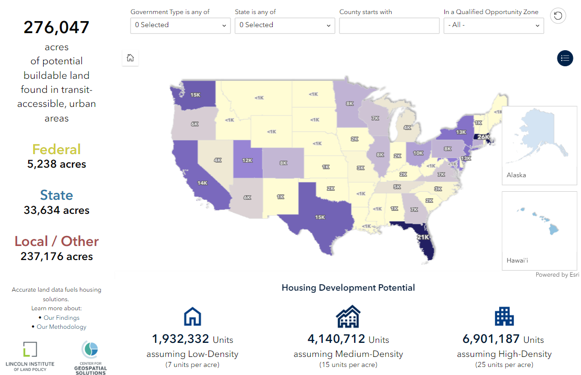
Some municipalities have begun to inventory their properties, but this can be a laborious and costly process. Geospatial solutions can help overcome these challenges by providing a unified and efficient approach to identifying and utilizing public land for new housing.

New work from the Center for Geospatial Solutions (CGS) provides a parcel-level examination of development potential on federal, state, and local land holdings. The findings, which leverage our Who Owns America® analysis, offer a comprehensive, data-driven assessment of development potential on government-owned land across the United States.

GettyImages-1405495418
1
2
3
4
5
Our Focus

Building Potential in Transit-Accessible Urban Areas

CGS examined parcel information alongside multiple authoritative public and proprietary sources to determine property ownership, narrow the study area, and evaluate each property’s likely usability.

Determining whether an individual parcel can support new development is difficult without local context. We took several steps to provide a rigorous estimate of total potential buildable land:

Key Findings

How much new housing could government-owned land support?

The Center for Geospatial Solutions identified over 276,000 acres of potential buildable land in transit-accessible urban areas. Our preliminary development calculations show this government-owned land could support over 1.9 million additional homes, transforming underutilized land into a swift, equitable, and sustainable solution for housing shortages.

Top Five States

With Greatest Housing Development Potential

  1. Massachusetts: ~25.8K acres
  2. Florida: ~20.8K acres
  3. Washington: ~15.9K acres
  4. Texas: ~15K acres
  5. California: ~14.6K acres

Total Potential Buildable Area

276 K+

Acres
Of usable, government-owned land nationwide

5200 +

Acres

Attributed to federal government agencies

33 K+

Acres

Attributed to state government agencies

237 K+

Acres

Attributed to local government agencies

Why It Matters

Accurate Land Data Fuels Housing Solutions

The better our understanding of land ownership across communities, the better we can identify and implement needed interventions. CGS provides essential data for identifying new opportunities for affordable housing development, but more is needed to turn potential into reality. 

GettyImages-1433633370-1

National Assessment: A Starting Point

The analysis is a comprehensive public assessment of federal, state, and local land holdings across the United States. This standardized national approach is valuable for municipalities and government agencies, providing a clear starting point for understanding public landholdings and potential use for housing development.

Local Partnership: Turning Potential into Reality

Local insights are crucial for validating and realizing the potential identified in this national analysis. Important factors like zoning rules, height restrictions, utility infrastructure, and redevelopment priorities vary greatly across communities.

A national, top-down approach only goes so far. On-the-ground context is essential to determine whether development potential can be acted on. Collaboration with local experts is needed to ensure that data is validated and effectively used to meet community needs.

INTERACTIVE MAP

Explore the Opportunity in Your Community

See how parcel-level insights can improve your understanding of local challenges and identify potential areas for redevelopment.

This free, interactive map makes it easy to: 

  • View potential buildable areas identified in the analysis 
  • Calculate how much new housing they could support assuming low-, medium-, and high-density development
  • Explore and narrow results by city and state
Screenshot 2024-07-15 184740

How We Did It

Our Methodology

CGS used the Who Owns America (WHOA) geospatial analysis to determine land ownership by federal, state, and local agencies. This approach examines parcel ownership to trace back 'true' ownership across geographic borders and corporate structures. By evaluating property ownership uniformly, WHOA sets a high-quality national baseline for deeper analysis, which was used to identify land suitable for housing development.

Just because land is owned by the government does not mean it is readily available to build new housing. Most publicly-owned land already has a valuable use, whether that’s hosting administrative buildings and transportation infrastructure or serving as protected space like conservation land.

To provide a standardized, national assessment of land use, CGS combined multiple authoritative sources to narrow the study area and help determine if a parcel could potentially support new development. 

Frequently Asked Questions

Who is this relevant to? expand_more

Policymakers, urban planners, nonprofits, the general public, and academic researchers can all find value in these results. 

What sources were used? expand_more

CGS integrated multiple authoritative public and proprietary data sources, including government records, ReGrid, the Census, and EPA Smart Locations Mapping.

How was land suitability determined? expand_more

CGS identified parcels in high-demand urban areas that were transit-accessible and, to the best of our ability, not currently in use for other purposes.

Is the land ready for development? expand_more

Our analysis was a preliminary estimate. More information is needed to determine if a property can truly support development. Local communities are best positioned to evaluate land suitability.

How did you determine if land was accessible by transit? expand_more

The analysis considers a property transit-accessible if it is within a quarter mile of a public transit stop with at least one trip per hour during the evening peak period.

I noticed a mistake, what does that mean? expand_more

The analysis is a valuable starting point but does not capture critical nuances such as zoning rules and development priorities. Local communities are best positioned to determine the suitability of land for development, balancing it against other public needs like recreation and conservation.

I'm interested in using this data. How can I learn more? expand_more

By working together with local experts, CGS ensures data is validated and used effectively to meet community needs, turning potential into tangible results.  Contact us to learn more. 

Additional information about our analysis and data layers of this analysis will soon be publicly available on esri’s Living Atlas. 

WHO OWNS AMERICA

Property Ownership Insights for Equitable Change

The housing crisis is not an insurmountable challenge. CGS equips communities across the country with the parcel-by-parcel information needed to take informed action on housing.

Explore how geospatial solutions can further your impact. 

who-owns-america-alt-content

Let's Rise to the Challenge

You’re on a mission to improve our world, we’re on call to help take you further. 

Looking for a partner in progress?
We’d love to hear from you.